SATree
OBJETIVE
The SATree Project, funded by the European Space Agency (ESA) and the Community of Madrid, aims to facilitate and optimize forest management by utilizing the European satellite network Copernicus. The project’s goal was to create a predictive model, based on satellite remote sensing and statistical processing through multivariate analysis of collected data, to generate an automatic mapping showing tree species, density, and distribution in forested areas using only the hyperspectral VIS-NIR images from ESA’s Sentinel-2 satellites.

DEVELOPMENT
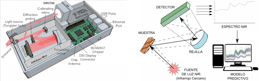
The innovative predictive model is based on a reference database of VIS-NIR spectra of analyzed species obtained on the Earth’s surface using a new spectrophotometer designed and developed entirely by Boscalia Technologies S.L. The internal components of the spectrophotometer consist of three modules with wavelength ranges similar to those of the sensors on the Sentinel-2 satellite: one from 360-1,100 nm and two modules from 1,350-1,650 nm and 1,750-2,150 nm.
As a result of implementing the algorithm obtained in the model into Geographic Information System (GIS) software, each set of intensity values for each pixel of the satellite image is automatically assigned a particular species or combination thereof. The final result forms a tree map that serves as a tool for forest managers to visualize the distribution of species and their changes over time, as well as other quantitative data of interest (areas, distances, or percentages).
Our SATree Project was the winner of the Copernicus Masters Award from the Community of Madrid in 2020..
SATree
OBJETIVE
The SATree Project, funded by the European Space Agency (ESA) and the Community of Madrid, aims to facilitate and optimize forest management by utilizing the European satellite network Copernicus. The project’s goal was to create a predictive model, based on satellite remote sensing and statistical processing through multivariate analysis of collected data, to generate an automatic mapping showing tree species, density, and distribution in forested areas using only the hyperspectral VIS-NIR images from ESA’s Sentinel-2 satellites.
DEVELOPMENT
The innovative predictive model is based on a reference database of VIS-NIR spectra of analyzed species obtained on the Earth’s surface using a new spectrophotometer designed and developed entirely by Boscalia Technologies S.L. The internal components of the spectrophotometer consist of three modules with wavelength ranges similar to those of the sensors on the Sentinel-2 satellite: one from 360-1,100 nm and two modules from 1,350-1,650 nm and 1,750-2,150 nm.
As a result of implementing the algorithm obtained in the model into Geographic Information System (GIS) software, each set of intensity values for each pixel of the satellite image is automatically assigned a particular species or combination thereof. The final result forms a tree map that serves as a tool for forest managers to visualize the distribution of species and their changes over time, as well as other quantitative data of interest (areas, distances, or percentages).
Our SATree Project was the winner of the Copernicus Masters Award from the Community of Madrid in 2020..